Where's the Trail in Colorado?
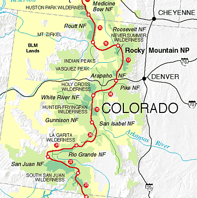
The designated route in Colorado
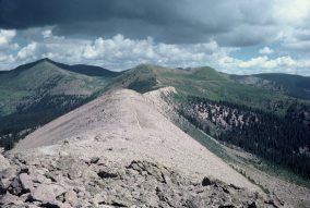
Along the Continental Divide in the San Juans
The Continental Divide Trail is approximately 650 miles in length in Colorado. Trail conditions in the backcountry are generally very good. The CDT route is located at high elevations, averaging about 10,000 feet.
The segments of the route, as described in Guide to the Continental Divide Trail, are:
The segments of the route, as described in Guide to the Continental Divide Trail, are:
- Mount Zirkel Wilderness Segment. A route in forested uplands along the Continental Divide, followed by some alpine hiking in the Mount Zirkel Wilderness.
- Rabbit Ears Range Segment. Private lands currently necessitate several miles on paved highway. Once back on the Divide, however, there is pleasant walking, with fine views from Parkview Mountain.
- Never Summer Range Segment. Owing to improvements of the designated route between Willow Creek Pass and Grand Lake, this segment (though attractive) is no longer part of the primary CDTS route.
- Front Range Segment. This skirts the edge of Rocky Mountain National Park and the Indian Peaks Wilderness. (However, the lengthier designated route, which climbs to the Divide and back down, is more scenic.) The CDTS route south of James Peak is excellent for hiker (but not horseback) use. This includes extremely rugged country -- very exposed to the elements -- that the designated route bypasses. Parry Peak (13,391') is the highest point along the traditional CDTS route, but the official Trail farther south has been improved and now provides a high-elevation route along the Continental Divide, including access to 14,270-foot Grays Peak.
- Vasquez-Gore Segment. The first half, mostly above timberline, follows recently improved tread. The CDTS route then takes rather poorly maintained path to the town of Silverthorne, continuing through wild country to the resort village of Copper Mountain. Portions are in the Vasquez Peak, Ptarmigan Peak, and Eagles Nest Wilderness Areas. (The designated route is being relocated off roads to a scenic high trail that tracks the Divide for several miles.)
- Sawatch Range Segment. Although the area includes Colorado's highest mountains, the trail follows their flanks, in forest. South of Twin Lakes, however, there are frequent nice stretches above timberline, including a relocation close to the Divide south of Cottonwood Pass. The segment includes portions of the Holy Cross, Mount Massive, and Collegiate Peaks Wilderness Areas.
- Cochetopa Hills Segment. Except for the first few miles, the route here coincides with the high-standard Colorado Trail. The terrain has gentler contours. While the trail often follows lightly-traveled (or closed) jeep roads, a more primitive, scenic, relocation is under review. A portion is in the La Garita Wilderness Area.
- San Juan Mountains Segment. This is excellent backcountry hiking around the head of the Rio Grande. The Weminuche Wilderness portion is especially popular; but the less crowded part between Spring Creek Pass and Stony Pass is delightful as well. Routes are generally in good condition. Snow may limit access from mid-October to late June.
- South San Juan Segment. About half of this is the South San Wilderness, consistently over 10,000 feet elevation. Trails may be difficult to follow at times. Snow conditions as in the San Juan Mountains Segment.
Enjoy the CDT by backpacking or hiking in Colorado.
[ Montana ] [ Wyoming ] [ New Mexico ]
[ Home ] [ Up ]