Where's the Trail in New Mexico?

Northern New Mexico
|
Southern New Mexico
|
Gila River
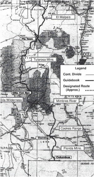
The CDTS route is approximately 650 miles in length in New Mexico. The designated route often tracks the Continental Divide more closely, but it misses many points of special scenic or historic interest.
The segments, as described in Guide to the Continental Divide Trail, are:
The segments, as described in Guide to the Continental Divide Trail, are:
- Carson National Forest Segment. The route follows the eastern perimeter of the Tierra Amarilla Grant and then continues south to Ghost Ranch. Recent improvements have moved most of the route to nonmotorized trails.
- Santa Fe National Forest Segment. The Forest Service has completed extensive relocations to new nonmotorized trails. The San Pedro Peaks Wilderness is the scenic and physical highpoint of the segment.
- Piedra Lumbre Segment. This is an isolated rolling section, on public lands administered by the Bureau of Land Management. BLM has done a fine job of marking an inviting trail location away from roads. Water availability is often of concern (as it continues to be, at least as far as Aragon Well in the Tularosa Mountains Segment).
- Mount Taylor Segment. Most of the segment is in the Cibola National Forest, largely on primitive roads. The CDTS route crosses the summit of Mount Taylor (11,301'), the highest point on the trail in New Mexico. An official route follows new footpath on the western flanks of the mountain.
- El Malpais Segment. The CDTS route traverses a portion of the Cibola National Forest, crosses the Malpais lava field, follows jeep road through the El Malpais National Conservation Area, and continues to Pie Town by way of county roads.
- Tularosa Mountains Segment. The route, largely on secondary roads, includes both forest and grassland settings. From Aragon Well (near NM 12), there are several springs as well as occasional windmills. (A relocation south of Wagontongue Mountain cuts down on the roadwalking, but parts of the CDTS route are still recommended because of its better access to water.)
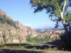
- Gila Wilderness Segment. The CDTS route follows deep canyons along the Gila River and its Middle Fork -- both with innumerable fords. Floods resulting from snowmelt or storms might occasionally give rise to hazardous conditions. The route passes the Gila Cliff Dwellings National Monument.
- Mimbres River Segment. The CDTS route follows an eastward course, on Gila National Forest trails, to the Black Range.
- Cookes Range Segment. The CDTS route employs county roads and cross-country travel on its way to the city of Deming. After leaving the Black Range, the trail crosses open grazing land. The ruins of old Fort Cummings, where army troops guarded the historic trail through Cookes Canyon, are of special interest. Windmills are the primary source of water.
- Florida Mountains Segment. The CDTS route terminates at the Mexican boundary near Columbus, New Mexico (a considerable distance east of the designated route to the state's "bootheel"). It includes an optional trackless climb at the southern end of the Florida Mountains, with opportunities to view introduced ibex. Water sources are once again limited.
Enjoy the CDT by backpacking or hiking in New Mexico.
[ Montana ] [ Wyoming ] [ Colorado ]
[ Home ] [ Up ]